Santa Giulia beach.
The southern shore of the gulf has stayed empty and wild. At the head of the gulf, sixteen hundred metres of sand, eight hundred of which form the sand bar closing off the lagoon — a sand bar its manager describes plainly as entirely taken over by tourist facilities.
A beach, a sand bar, a lagoon
The gulf of Santa Giulia lies entirely within the commune of Porto-Vecchio, on the eastern side of Corsica. It opens to the east, between the Punta di i Scogli Rossi to the north and the Ghjuncajola headland to the south, and on that side it is overlooked by the rocky massif of San Rafaellu, 253 metres high. The lagoon occupies the head of the gulf.
The beach is 1,600 metres long, 800 of which are formed by the sand spit — the lido — that closes off the lagoon. The Réseau d'Observation du Littoral de la Corse — the Corsican coastal observation network — describes it as “very narrow”, less than twenty metres of emerged sand, with a gentle slope; a channel, the grau, links the sea and the lagoon at the southern end of the spit.
To the north are the Marina di Santa Giulia and the small Petraggione beach; the long beach runs further south, with umbrella pines separating the sand from the lagoon. The northern end of the sand bar carries the marina, hotel complexes, rental residences and a holiday village.
From the estate
- Distance
- 18.2 km
- Drive
- 25 min by car
- Commune
- Porto-Vecchio, Corse-du-Sud
- Access to the protected site
- From the south, off the T10 road
The drive runs round the head of the gulf of Porto-Vecchio. From the town centre, the commune places Figari–Sud-Corse airport 23 km and half an hour away, and Bonifacio 27 km and half an hour as well: Santa Giulia sits on that axis, south of the town.
What the site's manager says
This is what sets Santa Giulia apart from its neighbours, and it is better read before going than after.
The Conservatoire du littoral writes that the sand bar is “entirely taken over and privatised by tourist facilities”. The southern shore of the gulf, by contrast, has remained empty and wild.
Access to the shore itself remains free: it is the maritime public domain. What you pay for here is parking — see below.
The network has been surveying this beach's profiles since 2002. It records a longitudinal variability of ten to twenty metres and a wide variability over time, which makes it hard to tell a temporary shift from a long-term trend. It also documents heavy pressure: numerous buildings and residences, and a rock revetment along the central part of the beach.
Dead Posidonia leaves pile up on the sand time and again and make access awkward. These banks are not a lapse in maintenance: they absorb the swell and protect the beach from erosion. The Conservatoire's protected site covers 293.49 hectares here, within the Extrême Sud coastal unit.
The lagoon, and what it requires
The lagoon covers 23.13 hectares, with a catchment of 15.5 km². It is no more than 1.5 metres deep in winter and never dries out completely in summer. Summer evaporation, of the order of a centimetre a day, produces a seasonal inversion: low in salt in winter, the water becomes hypersaline in summer. Its feeders include the Lezza and the Alzellu.
It has belonged to the Conservatoire du littoral since 1981 and, since 2007, has been managed by the Office de l'Environnement de la Corse under delegation from the Collectivité de Corse, jointly with the Bouches de Bonifacio nature reserve. It is designated under both the Habitats and the Birds Directives of the Natura 2000 network, and as a type I ZNIEFF under the number 940004106.
You will find here the remnants of a Phoenician juniper sand bar, reed and rush beds around the lagoon, a wooded massif at Ghjuncajola mixing century-old junipers with cork-oak maquis, Ruppia beds in the lagoon and glasswort salt flats. Fifty-six bird species have been recorded; the lagoon takes in wintering greater flamingos, as well as the Corsican toothcarp, a protected fish, the Balearic green toad and eels.
What that means for a visitor:
- camping, bivouacking, fires, dumping waste and motor vehicles are prohibited on the Conservatoire's land;
- movement off the waymarked paths is prohibited — the lagoon and the sand bar are not to be crossed by cutting through;
- landing on the islets is prohibited;
- two paths, on the other hand, have been laid out, one through the Ghjuncajola massif and one at the Punta di l'Oru, to show “another side of the site, away from the tourist facilities”; the one in the massif is listed as undergoing repair.
Swimming
The supervised bathing zone runs for 730 metres, from the path to the Moby Dick tennis courts in the south to the access channel to the Club Med pontoon in the north. The lifeguard post and the public toilets stand near the Bar Plage; supervision is provided in high season — the commune publishes no dates: do not assume lifeguards are on duty.
The beach holds the “Una Piaghja per Tutti” label at level 2, which means precisely an access mat and an amphibious chair, but not the adapted sanitary facilities of level 3. The car park is close by and the access path can be used in a wheelchair; the amphibious chair is kept at the lifeguard post, so its availability follows that of the lifeguards. Corsica has 68 inclusive beaches, each signposted with a standard panel stating its level.
Since 29 June 2025, smoking has been prohibited on beaches bordering bathing waters during the bathing season. The same measure applies to public parks and gardens, bus shelters and the surroundings of sports facilities and schools.
On water quality, the regional health agency publishes an annual review: close to 1,800 checks across 229 sites listed at European level for the 2025 season, 173 of them at sea and 56 in fresh water, 88% of bathing sites compliant with European requirements, and 91% of excellent quality at sea against only 21% in fresh water. The 2026 bathing season opened on 15 June.
In rivers, however
The gap between sea and fresh water in that review is not an abstraction: it directly concerns the three communes around the estate. For the 2026 season, the regional health agency states that bathing is prohibited or to be avoided on a permanent basis, for degraded quality or safety risk, at the following sites:
- at Lecci: upstream of the reservoir, Mulinacciu and Mura di l'Onda;
- at Porto-Vecchio: Alzu-di-Gallina;
- at Zonza: Pisciarone.
We would rather write it than leave it out: these are exactly the pools you pass on the way inland.
The monitored watercourses of the area are covered on the Bavella Needles page.
Parking
Parking is on a private car park roughly 200 metres from the beach, charged as a flat daily rate, with a different scale for cars, motorbikes and campervans. Entry is between 9 a.m. and 5 p.m., exit is free through an automatic barrier, and the ticket remains valid if you leave and come back the same day. Barbecues are strictly prohibited for campervans. These conditions are published by the operator of the car park and may change from one season to the next.
What surrounds the gulf
To the south lies the Bouches de Bonifacio nature reserve, created by decree of 23 September 1999: 79,460 hectares across five communes — Bonifacio, Figari, Monacia-d'Aullène, Pianottoli-Caldarello and Porto-Vecchio — which makes it the largest nature reserve in mainland France. It runs from the Moines and Bruzzi islands in the west to the Chiappa headland in the east, and is managed by the Office de l'Environnement de la Corse.
Its rules prohibit fishing in the no-take zones, along with the taking of fan mussels and date mussels; scuba diving is prohibited in the reinforced protection zone and subject to authorisation in the no-take zone; anchoring and coming alongside are regulated by order of the maritime prefect, and landing is prohibited except on the Lavezzi island, the Pyramide islet, the Piana island and the edges of the lagoons. Anchoring by vessels of 24 metres and over is governed by a maritime prefectural order of 23 May 2024, motivated by damage to the Posidonia meadows.
A word, finally, about rankings, since they are everywhere: Santa Giulia comes 46th in the 2025 “The World's 50 Best Beaches” list, drawn up from the votes of more than a thousand travel professionals against eight criteria. That is a private ranking, not an official distinction. And since two claims come up everywhere about the beaches here: UNESCO draws up no ranking of beaches, and no Porto-Vecchio beach appeared in the 2025 Blue Flag list.
Sources
- Conservatoire du littoral, Santa Giulia site factsheet;
- Réseau d'Observation du Littoral de la Corse, Santa-Giulia factsheet;
- Pôle-relais lagunes méditerranéennes, Santa Giulia lagoon factsheet;
- commune of Porto-Vecchio, “Les plages”;
- ARS de Corse, annual review of bathing water quality, 2026 edition;
- Légifrance, decree of 23 September 1999 creating the Bouches de Bonifacio nature reserve, and decree no. 2025-582 of 27 June 2025 on smoke-free spaces;
- Agence du Tourisme de la Corse, “Una Piaghja per Tutti” label.
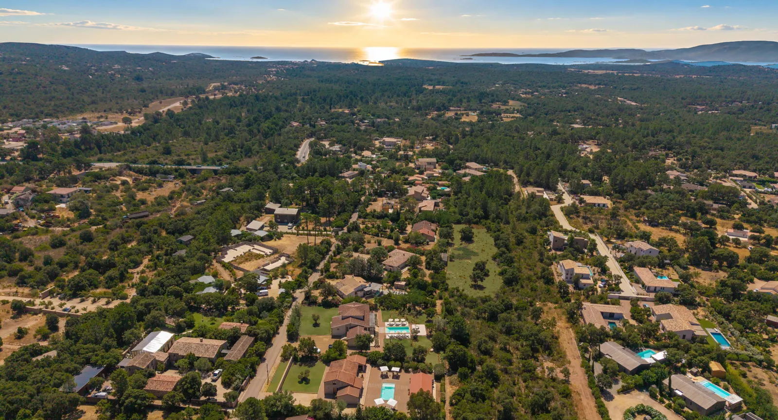
As no photograph of Santa Giulia under a usable licence could be found, the only view on this page is of the estate itself: we would rather show an honest image than one of somewhere else.
Distances and drive times given from the estate are calculated point to point over the road network, from coordinates recorded on OpenStreetMap; they are not estimates.
The two houses currently open
Ô6 · Le Couchant — three bedrooms, in the Oso valley.
Ô1 · L'Aube — five bedrooms, on the same estate.
The other surroundings
Palombaggia beach — the porphyry headland and its coves, further north.
Bavella Needles — the mountains, inland.
The places around the estate are on the surroundings map.
Booking
The calendar and the real availability of both houses are on the home page.