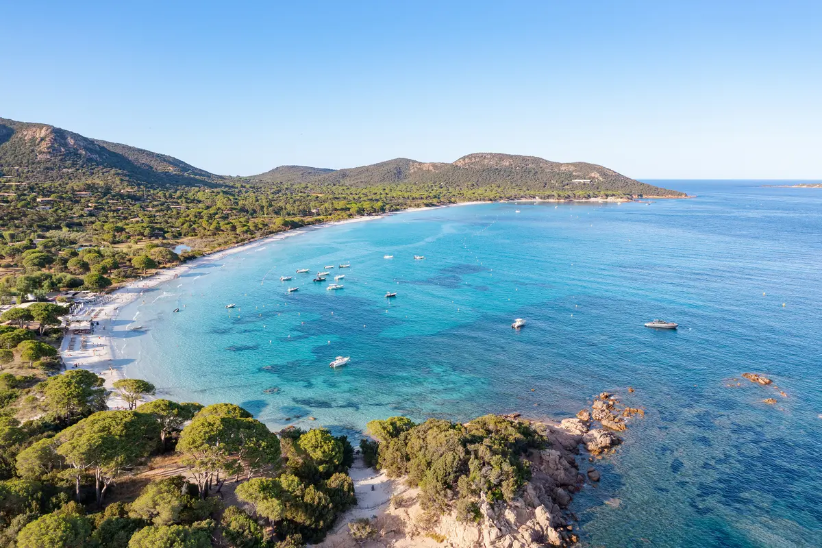
Palombaggia beach.
What people call “Palombaggia” is not one beach but a string of coves either side of a rocky headland. Here is what the people who manage the site say about it, and what is worth knowing before you drive down.
One headland, two beaches
At the heart of the site stands the Punta Columbara, a rocky headland of red porphyry. The far ends of two large beaches of very fine sand come to rest against it: Palombaggia beach on one side, Tamaricciu-Acciaghju on the other.
You are not looking for a beach here — you are choosing a cove.
Two of these areas belong to the Conservatoire du littoral, in the commune of Porto-Vecchio: Palumbaggia, 18.22 hectares, and Tamaricciu, 9.76 hectares, both within the coastal unit of the gulf of Porto-Vecchio.
The Conservatoire describes pale granite eroded into boulders, century-old umbrella pines and maquis of juniper and cistus. Behind the sand, wetlands serve as breeding grounds for amphibians — the Tyrrhenian painted frog and the Balearic green toad. On the Tamaricciu side, fixed dunes rise to twelve metres and overlook a small wetland fringed with reeds, rushes and tamarisk; that site is open to the public along a walking loop of roughly one hour.
From the estate
- Distance
- 21.4 km
- Drive
- 28 min by car
- Commune
- Porto-Vecchio, Corse-du-Sud
- Road
- Communal road CC 17, the “route de Palombaggia”
The beaches are not served by a departmental road but by a communal one: the CC 17, which loops between Porto-Vecchio, Piccovaggia and Bocca dell'Oro. You reach the sand by its branches — the CC 48, route d'I Pini, goes down to Palombaggia beach; the CC 49a is the chemin de Tamaricciu; the CC 49, chemin des Lumières, leads to Cala di Lume beach. The CC 17b, route de la Chiappa, runs from Piccovaggia towards the lighthouse. The main roads in the area are the RT 10, between Bastia and Bonifacio, and the RD 859 towards Sotta and Figari.
From the centre of Porto-Vecchio, the commune publishes its own distances: Lecci 12 km and a quarter of an hour; Figari–Sud-Corse airport 23 km and half an hour; Bonifacio 27 km and half an hour as well.
Parking
This is what most pages about this beach get wrong.
Parking is chargeable both on the beach car parks and on the public road around the Palombaggia loop, seven days a week, from 1 January to 31 December, between 9 a.m. and 7 p.m., according to the May 2025 report to the municipal council, which states explicitly that there is no free period in these two zones — unlike the first few minutes offered in the town centre. Failure to pay incurs a fixed penalty (the French forfait post-stationnement).
Holders of a French “mobilité inclusion — stationnement” card or of a European parking card are exempt across all chargeable spaces, on production of the document. The scale of charges is set by a decision of the municipal council and is revised from time to time: check it on the commune's own site, not in a guidebook.
The commune has also laid out 380 spaces between Acciaghju and Casa di Lume, in four phases, with signage, road markings and devices preventing parking outside marked bays, zones limited to 30 km/h and shared-space zones at 20 km/h, traffic remaining two-way. The stated reason is blunt: to put an end to the disorderly parking that was obstructing emergency vehicles. So do not pull onto the verge.
Swimming and water quality
The lifeguard post stands where the chemin de Casa di Lume reaches the shore, on the southern part of the beach; the supervised zone extends 400 metres either side of the post. The public toilets are at the northern end, near the I Pini car park. Supervision is provided in high season — the commune publishes no dates: do not assume lifeguards are on duty.
The commune documents three facilities for people with reduced mobility: a car park nearby, a path to the water usable in a wheelchair and an amphibious chair at the lifeguard post, whose availability therefore follows that of the lifeguards. It documents no adapted sanitary facilities at this site.
For the 2025 season, the “Palombaggia” sampling point was classified as excellent quality by the French Ministry of Health, on eleven samples; Folaca, the southern cove of the same stretch, holds the same classification. The commune states that it cleans its beaches by hand in order to preserve the Posidonia seagrass meadow, and has the water quality analysed weekly through the summer.
What is protected, and what that changes
The area lies within the Natura 2000 site “Îles Cerbicale et frange littorale” (FR9400587), 3,697 hectares in the commune of Porto-Vecchio, designated under the Habitats Directive. The dunes of Palombaggia, Tamaricciu and Acciaghju are part of it. The site's priority habitat is the Posidonia seagrass meadow; an endemic plant, Silene velutina, and endemic Tyrrhenian lizards are also listed there. The Conservatoire du littoral reports that a loggerhead turtle nest was recorded here in 2002, described as the first documented marine turtle breeding event in Corsica.
On Conservatoire land, camping, fires, dumping waste and driving motor vehicles are prohibited. Given the heavy summer pressure, the Conservatoire states that its priorities are removing unauthorised structures, controlling vehicle movement and fencing off the dunes against erosion and trampling. Management is carried out by the Office de l'Environnement de la Corse, delegated by the Collectivité de Corse, jointly with the Bouches de Bonifacio nature reserve.
The archipelago you can see offshore, however, is a nature reserve: the Cerbicale islands, designated by decree of 3 March 1981, roughly 36 hectares across five islands and islets — Forana, Piana, Maestro Maria (the Île Plate), Pietricaggiosa and the Vacca islet. The decree prohibits landing, movement and remaining on the four main islands from 1 April to 31 August, and all year round on the Vacca islet; motor vehicles are prohibited at all times, as are camping, hunting and any sporting or tourist event.
The beach itself is not a nature reserve. The islands offshore are, and so is the marine area further out to sea.
The Chiappa lighthouse
At the end of the CC 17b, on the Chiappa headland, a square tower of exposed stone masonry carries its focal plane 64.5 metres above the sea. It was built following the 1837 law on maritime signalling in Corsica, and first lit in 1845; the architecture is attributed to Léonce Reynaud. Now automated, the light shows groups of three flashes then one, every fifteen seconds, with a range of twenty-three nautical miles. It is state property and is not advertised as open to visitors: it is something you look at from outside, and not all the surrounding land is public.
In the same stretch, the commune lists the beaches of Tamaricciu, Acciaghju, la Chiappa, Santa Giulia and Porto Novo, together with the gulf of Stagnolu and Golfu di Sognu. La Rondinara, often attributed to Porto-Vecchio in guidebooks, is in fact in the commune of Bonifacio.
Sources
- Conservatoire du littoral, site factsheets for Palumbaggia and Tamaricciu;
- Natura 2000 in Corsica, factsheet for site FR9400587 “Îles Cerbicale et frange littorale”;
- Légifrance, decree no. 81-205 of 3 March 1981 creating the Cerbicale islands nature reserve;
- commune of Porto-Vecchio, “Les plages”, the works on the loop road, the transport factsheet and the council report on parking regulation;
- French Ministry of Health, bathing water classification, 2025 season;
- Plateforme ouverte du patrimoine, Mérimée entry IA2A001278 for the Chiappa lighthouse.
Distances and drive times given from the estate are calculated point to point over the road network, from coordinates recorded on OpenStreetMap; they are not estimates.
The two houses currently open
Ô6 · Le Couchant — three bedrooms, in the Oso valley.
Ô1 · L'Aube — five bedrooms, on the same estate.
The other surroundings
Santa Giulia beach — the sand bar and its lagoon, further south.
Bavella Needles — the mountains, inland.
The places around the estate are on the surroundings map.
Booking
The calendar and the real availability of both houses are on the home page.